[Content of map collection introduction] What can be seen from "Soil measurement map" and "shipment restriction map"
Hello everyone! Thank you for your support.
By the way, our staff members also do their best in editing work every day.
And gradually it has become possible to introduce the contents to everyone.
Today, I will introduce one figure from Chapter 2, "Food" Analysis Corner.
And gradually it has become possible to introduce the contents to everyone.
Today, I will introduce one figure from Chapter 2, "Food" Analysis Corner.
Thus, in this map collection, we utilize the measurement result of soil measurement project of 17 prefectures,
We are also trying to analyze the relationship between "soil pollution" and "food" pollution.
--------------------------------------------------------
--------------------------------------------------------
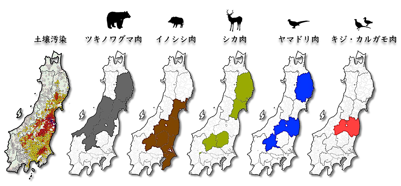
This figure is an easy-to-see array of areas with soil contamination and shipment restrictions on "wild birds and beasts".
Unlike so-called “agricultural products” such as vegetables and fruits that can be harvested in the fields, which are mostly undetectable except for a part now, wild mushrooms and wild vegetables, and boars, deer and bears feeding on them Radioactive cesium that exceeds the standard value is detected even now as of 2018 from "Wild birds and beasts meat", and shipping restrictions are instructed under the name of "Nuclear Disaster Countermeasures Special Measures Act" .
And if you look at the map, there is also a close correlation between the cesium concentration and the limited shipping area.
However, there are some provinces that are not subject to shipping restrictions despite their neighboring provinces.
Well, here is the problem.
What do you think is the reason why shipping restrictions do not apply to these prefectures?
What do you think is the reason why shipping restrictions do not apply to these prefectures?
1) As a result of measuring the animal, it is not found anything exceeding the standard value.
2) Because the measurement of the animal is not performed, it does not result in detection and reference value exceeding in the first place.
3) The animal was measured and it was confirmed that the standard value was exceeded, but shipping restriction was not instructed by "the circumstances of adults".
[Hint] There are no nationally defined regulations on what foods each prefecture measures at what frequency, and inspections are conducted based on the plans of each prefecture. Therefore the policy is different. The detection lower limit of measurement also varies.
→ Please check the answer in the map collection.
******************************
"" Illustration "Collection of 17 metropolitan prefecture radioactivity measurement maps" bookmaking crowdfunding
It is underway until September 28!
It is underway until September 28!
What is the situation like the huge amount of radioactivity released in the Fukushima nuclear accident that caused the world's unparalleled radioactive contamination?
More than 4,000 citizens cooperate with more than 4,000 people in soil in more than 3,400 soils in 17 prefectures, and the measurement room will try to publish a book that illustrates and explains enormous data collected and collected in one place. Thing.
More than 4,000 citizens cooperate with more than 4,000 people in soil in more than 3,400 soils in 17 prefectures, and the measurement room will try to publish a book that illustrates and explains enormous data collected and collected in one place. Thing.
Continue to share, thank you for your support.
https://motion-gallery.net/projects/minnanods
https://motion-gallery.net/projects/minnanods