Why I started this project-hotspots are abandoned!
“ East Japan 17 prefectures soil Becquerel measurement project” The soil project was a project aimed at comparing common pollutions in different places.
Therefore, micro hotspots that exist in various places were excluded from the measurement targets.
However, the environment "micro hot spots" where radioactive materials are concentrated to a high concentration, which are scattered everywhere, are also not negligible.
It was impossible for us to work on both projects simultaneously, so the hotspot project worked with a trusted team.
That team, the Hotspot investigators for Truth(HIT), is working on its own to find and locate hotspots, measure air dose and soil contamination, notify the government and encourage improvement.
We have developed an environmental enrichment page so that the data measured by HIT can be published on the data site website.
We hope that everyone will know what kind of place is likely to be a hotspot and use it for everyday life.
Here, Mr. Sugar Nat, who is the representative of the HIT, gave a note on why he started the activity to measure environmental concentration and the content of the activity.
Project opportunity
Author: Hotspot Investigators for Truth Representative Sugar Nat
The opportunity goes back to the beginning of 2012. It was in January 2012 that the Ministry of the Environment formulated a full-scale decontamination field plan and created decontamination guidelines and special measures law.
After that, the word "0.23μSv / h" suddenly appeared in the newspaper.
Because I did not understand the meaning well, I examined it.
According to the “Guidelines for investigation and measurement methods of environmental pollution in the priority area of pollution situation (May. 2nd edition)” (pages 1-9 to 1–10) established by the Ministry of the Environment At the center, it is judged in area units such as block or section of village.
Air dose is measured at height of 1 meter at multiple measurement points of each area, and its average value is over 0.23 μSv / h , It will be the target of the development of the decontamination implementation plan.
The average height is 1 m or less and 0.23 μSv / h or less in one division unit of one municipality.
At that time, it was clearly stated that “Because the purpose is to know the average dose in the area, the point where the dose may be high locally, such as the bottom of a tree or a ditch, is not considered as the measurement point.” .
I found that "Select area units such as detailed blocks as far as possible, taking into consideration the circumstances of each municipality
After deciding on it, decide the area where you will actually conduct survey and measurement. Existing conditions such as aircraft monitoring
For areas where it is clear that the result of the review falls under or does not fall under the planning requirements,
There is no need for additional survey measurements." in the guideline.
In other words, it meant that "a lot of hotspots don't have to be managed actively", so I was very concerned that "a hotspot could be abandoned!"
As far as I know, even though the country describes places that are likely to be hotspots, it has not created any database of hotspots, and I was also concerned about this.
Hot spot standards-Ambiguity of air dose standards-
As a standard that MEXT or the Ministry of the Environment treats as a hot spot, if it is not a condition that "the value measured just above the hot spot is 1 μSv / h or more" in addition to "the value of The guidelines say that you do not have to When I saw this criterion higher than 0.23 μSv / h, I clearly understood that many hotspots would be discarded without being addressed. The concern was realized in 2012. I was interested in seeing a hot spot on a riverbed in Edogawa Ward on the Youtube post of the general public, so I actually measured the air dose by myself. When I applied for decontamination to Edogawa Ward with the result, it is said that "If it is 1m Sv / h value, decontamination will not be performed. There is no problem because it is a very narrow range." It was At that time, when the soil of the hot spot was collected at a depth of approximately 5 cm and measured by becquerel, it was about 34,000 Bq / kg in around August 2012. There was thing of designated waste level, but it is the situation that the hotspot still remains without being dealt with. At that time, the air dose in that place was about 0.5μSv / h in 1m and 2.5μSv / h on the ground, as measured by Geiger counter. The air dose standard confirmed that the hazard was neglected.
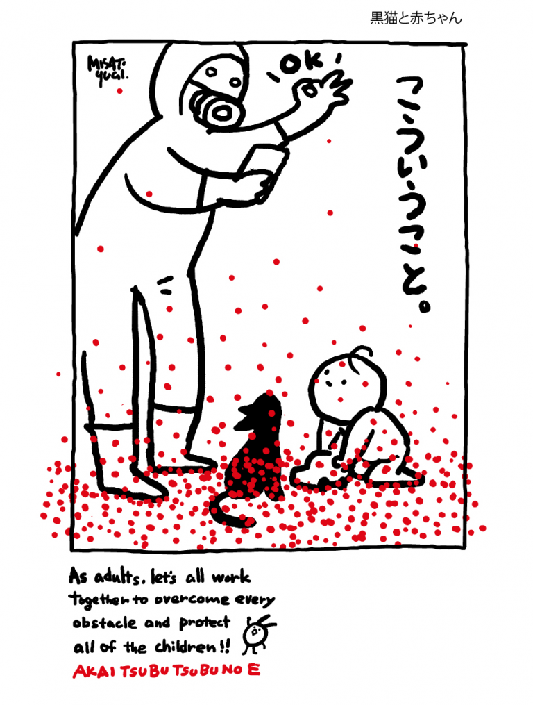
This illustration shows that measurements of one meter above the ground can not tell the exact contamination, as more radioactive material is present near the surface.
(Illustration by Misato Yugi)
Let's start what I can do!
In the wake of this, in 2012, we started the hotspot verification on our own. if you look at the places of interest with reference to Youtube etc., it can be confirmed that the places where the concentration differences of radioactive. Then, in order to have the local government and the country deal with this hotspot that has not been dealt with, we thought that we could do a project to take evidence, and with the cooperation of many people Becquerel Measurement Project has started. In this project, we will collect hot spot substances and measure the "becquerel value". In addition, the air dose "μSv / h value" is also recorded firmly on the spot to see the correlation. Record the area and depth of the hot spot, and divide it into 12 types of sampled situation, such as "soil, moss, or black material". I also take photos to keep track of what places are hot spots. As far as possible, measure and record the surrounding air dose, and also record how much the air dose is higher or not compared with the surrounding area. In this way, the accumulated records can be viewed by our website.
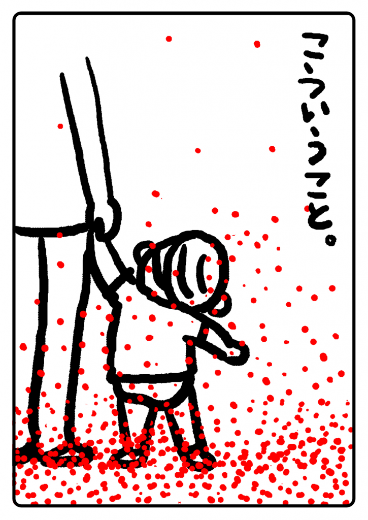
This illustration states that children who are shorter than adults are at greater risk of being exposed to more radioactive material.
Illustration by Misato Yugi.
For children, request your local government for decontamination cooperation!
One of the goals of this project is to leave it as a database, and one for many abandoned hotspots, and ask the local authorities for the best possible care and cooperate in decontamination.
Through this project, we would like to let you know what features are likely to be hotspots, and use this data to alert you in your area. From the actual air dose of the hot spot and the result of the becquerel measurement, it was confirmed again that the hotspot with extremely strong contamination was overlooked and left alone by the value of air dose at a height of 1 m alone . Public-private partnerships where citizens measure and report these facts to the local government and have them decontaminated it was a shortcut to eliminate pollution in the end, as it was a roundabout, and the measurement of these detailed places that the local government did not do was eventually a detour.
In this project, I brought in the measurement results to several municipalities by myself, and have negotiated tenaciously such as decontamination. In some municipalities, we were able to get decontamination actually. However, what I found through many negotiations is that it is easier for us to listen to requests from residents of the local government / working people. Not being an outsider, raising voices in the area is the driving force that drives the municipality. With this project as a trigger, I hope that it will be possible to connect with as many citizens as possible about measures against hotspots, and to spread to request cooperation from the local government. Let's hold hands and lead for the safety of children. Thank you for your cooperation.
Hotspot Investigators for Truth