Method of Soil Collection
We asked the public for cooperation from October 2014 to the end of January 2017.
Coducted the unified collection way as follows:
Preparation before collection
1. Prepare the tools needed for collection.
2. Read and confirm the collection tool and collection method manual. (<Tools and methods for collecting detailed manual PDF>)
3. Print the required number of notes and vouchers. Look over how to write the field note.
4. Confirmed how to take location information (latitude and longitude).
5. Confirming the weather forecast.
Take a look!
Manual for Collection a Sample
1) Confirmation of collection place and conditions
○ Please collect after the sunny weather continues as possible. If the soil is dry it is fine even after the rain.
○ Using an air dose meter, grasp the rough dose in the vicinity. Extremely high dose hotspots (singular points), for example, soils and gravels that are under rain gutters or in gutters, should NOT be defined as sampling points.
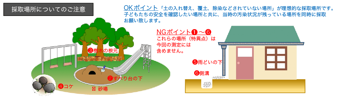
Illustration shows where is the appropriate point or not to collect the soil sample.
2) Prepare a Field Note (recording paper) and a Slip
Please fill in the field notes as much as possible.
In the field note, there are items to be published actually and items to be filled in but not disclosed. Please check the field note column for public and private.
Also, if you record in detail the topography, geology, surrounding environment (whether there are trees, near water, slopes, etc.), we can guess later why the measured values are the same.
After that, please attach a rough map of the site and a photo (mail or email attachment).
For people in the measurement room where it is difficult to visit the site again and those who analyze it, and also when it turns out that there is a big difference compared with other surrounding figures later, etc. Since it is the record of the field book to be a clue, please record carefully.
Print out the slip, write the date of collection and the name of the place, and place it in a double plastic bag containing the soil sample.
3) Measurement of air dose (not mandatory, but please measure if you can)
The air dose at the sampling point is measured at 2 points 5 cm above ground and 1 m above ground, and recorded along with the type of space dosimeter you use in the field note.
It is best to measure both 5cm and 1m on the ground three times and write the average value.
You may measure both 5cm and 1m above the ground once and write the value.
If you do not have time, please measure the value of 5 cm above the ground only once.
If you can not do air dose measurement, you can leave it blank.
4) Confirmation and description of latitude and longitude information (GPS)
In this project, one of the goals is to map measured values at many points. Therefore, we ask for the description of latitude and longitude information in the field note. Latitude and longitude have two kinds of notation, decimal system and decimal system (frequency), but this project adopts decimal system (eg N35.303485 E139.932404 etc.).
A) If you want to record the latitude and longitude on the spot => You can check with your smartphone.
In general, applications in the 60-decimal notation account for a large number, so we have developed a web page that can obtain decimal latitude and longitude and an address. Please use all means. https://kodomira.sakura.ne.jp/map/digital_yacho/
The point of use is:
1. GPS information You will be asked for permission, such as "Is it OK to send out?" Please select "Allow (Yes)".
2. In a building or near a building, it can not pick up radio waves and may indicate a different place at all.
Once you launch the pure google map app and load the same page again, you may see better results.
Also, we will introduce an example of the decimal notation iPhone · Android application that can be downloaded and used.
-In the case of iPhone (an example of application: "MapMemo")
-In the case of Android (an example of application: "GPS simple (GPS Status)")
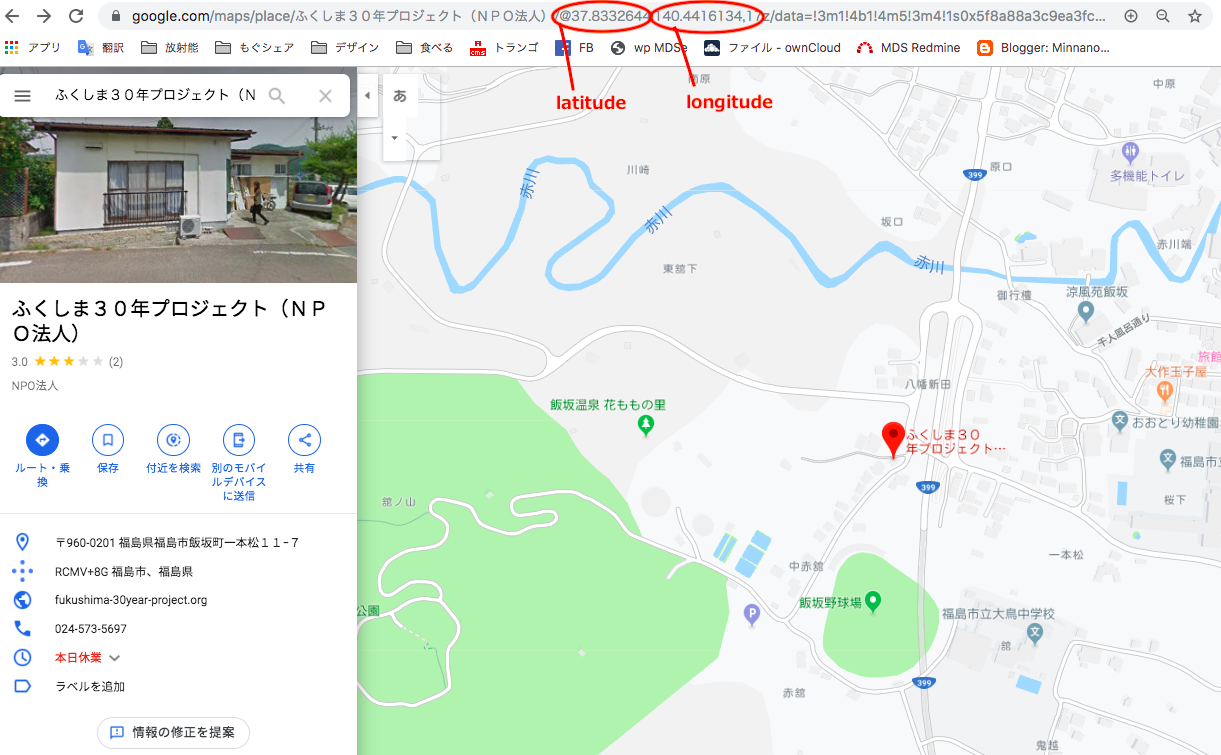
B) If you know the address => Search Google map on your PC and check the URL.
Open the google map on the Internet and search for the destination (address etc.). Then, the latitude and longitude are displayed at the URL, as shown in the figure, so please write those numbers in the field book. By the way, numbers in the 30 to 40 degrees are north latitude (N) and numbers in the 130 to 140 degrees are east longitude (E). When publishing as a map on a data site, please indicate up to 3 decimal places, as it will only be published to 3 decimal places.
GPS tools is necessary to record where is the collection point.
5) Confirm how to dig and collect
Let's prevent suction and adhesion during work with rubber gloves, mask, goggles in high dose areas
1. Avoid if there is sand on the surface (ground etc.).
2. Take a volume of just over 1 liter from the surface exactly 5 cm deep. (Example: 10 centimeters by 20 centimeters of rectangular solid will be approximately 1 liter)

How to dig and collect the soil. 5cm depth and square shape is our standard.
3. Remove large branches, leaves, stones and roots. The place with a lot of stones will be washed away.
4. Put the soil in a doubled plastic bag and stir well (very important to equalize the concentration of radioactive material).
5. Vent the air, secure the mouth of the bag, place it in a zippered plastic bag, make sure it has a slip filled in between to make it visible, and close the mouth tightly.
6. Fill the hole after extraction with surrounding soil and flatten it. (The collected soil will be returned to the person who collected it after the measurement, so please return it to the place where it was originally.)
7. Wash the used tools each time (or remove the dirt with a wet towel etc.) and do not mix with the soil of the next point.
6) Sending of collected soil
Make sure that the soil collected is enclosed in a completed slip.
Put the soil and note in a cardboard box, pack it and send it to the designated measurement room.
Frequently Asked Questions
Q: What should I do on rainy days or wet soil?
A: If it was raining on the day you planned to collect, we recommend changing the date if possible.
If you can only get that day, spread the soil on a newspaper and remove moisture before measuring.
When soaking up during drying, or when breaking up the soil that has once dried and solidified again and packing it in a bag,
there is a concern that the dirt will dance and so on, so it is not recommended if it is difficult.
The moisture content is preferably less than 10%, but it is almost okay if it is not sticky.